Geodetic Astrology vs Astrocartography: What’s the Difference?


- Geodetic astrology gives every place on Earth its own zodiac degree, based on its longitude. It doesn’t need your birth chart.
- Astrocartography starts from your birth chart and shows where your planets are strongest on the map.
- Geodetic describes a place. Astrocartography describes you in that place.
- Use them together: your map to shortlist, a city’s geodetic degree as a second layer, and your relocated chart for the final read.
Wanna know the difference between geodetic astrology and astrocartography? They actually work hand in hand if you’re thinking of moving to a new city. There’s a reason you are pulled towards there, and geodetic astrology can explain that!
What is geodetic astrology?
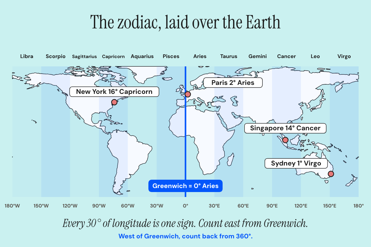
Geodetic astrology lays the zodiac over the Earth. The British astrologer Sepharial, whose real name was Walter Gorn Old, set out the method in his 1925 book The Theory of Geodetic Equivalents.
The rule is simple:
- The Greenwich meridian (0° longitude) is 0° Aries.
- You count east from there. Every 30° of longitude is one zodiac sign.
- For places west of Greenwich, you subtract the longitude from 360°.
So every place gets its own zodiac degree, and that degree never changes. It’s tied to the place, not to a person.
| Place | Longitude | Geodetic degree |
|---|---|---|
| Greenwich | 0° | 0° Aries |
| Paris | 2°E | 2° Aries |
| Singapore | 104°E | 14° Cancer |
| Ubud, Bali | 115°E | 25° Cancer |
| Tokyo | 140°E | 20° Leo |
| Sydney | 151°E | 1° Virgo |
| New York | 74°W | 16° Capricorn |
| Los Angeles | 118°W | 2° Sagittarius |
Rounded to the nearest degree.
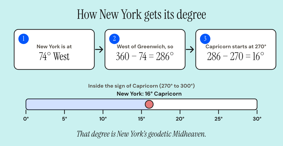
That degree is the place’s geodetic Midheaven. A full geodetic chart then works out an Ascendant for the place’s latitude, the same way any chart does.
The big difference: the place or you
This is the part to remember.
| Geodetic astrology | Astrocartography | |
|---|---|---|
| Starts from | The Earth’s coordinates | Your birth chart |
| Needs your birth details? | No | Yes |
| Same for everyone? | Yes. A city’s geodetic chart is fixed | No. Your map is only yours |
| The question it answers | What is this place like? | What is this place like for me? |
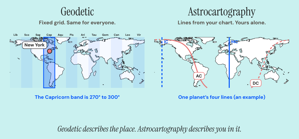
Geodetic is the baseline of a place. Astrocartography is how your own chart meets it. Jim Lewis developed astrocartography, and it plots every spot on Earth where each of your planets sat on an angle at the moment you were born.
What they have in common
Both belong to locational astrology, the branch that reads places instead of just charts. Both use the four angles. And on both maps, the Midheaven shows up as a straight north to south line.
But the lines don’t mean the same thing. On your astrocartography map, a Midheaven line is where one of your planets was at the top of the sky. On a geodetic map, a Midheaven line is where the zodiac degree for that longitude sits. They can fall in the same place, but they’re answering different questions.
It’s older than 1925
Geodetic astrology didn’t come out of nowhere. Medieval astrologers already tied signs to regions. In his Flowers, Abu Ma’shar describes a planet’s effect appearing in the cities that fall under a sign’s division of the world, and Dykes’ translation points to a separate tradition of geography for where each sign’s regions lie (Dykes, Astrology of the World II, pp. 305 to 306).
Sepharial’s step was to make the link exact. Instead of broad regions, every degree of longitude gets a zodiac degree.
How to use them together
Here’s a simple way to combine them.
- Start with your astrocartography map. Use it to shortlist places where your planets are strong.
- Look up each city’s geodetic degree. Then see whether any of your natal planets sit close to it. Astrologers who use geodetic read that as the place and the person lining up.
- Finish with a relocated chart. That’s still the actual reading for a city. Here’s what a relocated chart is.
Say you have Venus at 14° Cancer. Singapore’s geodetic degree is also 14° Cancer, so a geodetic astrologer would flag Singapore as a place where your Venus has something to say. It’s an extra layer on top of your map, not a replacement for it.
What to keep in mind
Geodetic systems vary. Astrologers don’t all start the count in the same place or use the same zodiac, so two geodetic maps can disagree. Check which system yours uses. The standard Sepharial version uses the tropical zodiac.
It’s also a symbolic system. It describes the themes a place carries, not what will happen to you there. Treat it as one input alongside your budget, visa, climate, language and family.
If you’d like both read for you, you can book a reading. We also use geodetic analysis in our corporate work.
Find your cities
The AstroNat travel app shows where your lines fall and which places are worth a closer look, with 3 free city readings.
Open The Travel App →Geodetic astrology FAQ
What is geodetic astrology?
A system that matches each place on Earth to a zodiac degree, based on its longitude. It’s the same for everyone and doesn’t use a birth chart.
Who invented geodetic astrology?
Sepharial (Walter Gorn Old) set out the method in his 1925 book The Theory of Geodetic Equivalents.
Is geodetic astrology the same as astrocartography?
No. Geodetic starts from the place. Astrocartography starts from your birth chart and shows where your own planets are strongest.
Do I need my birth chart for geodetic astrology?
Not to find a place’s geodetic degree. You only need it if you want to compare your planets to that degree.
What zodiac does geodetic astrology use?
The standard Sepharial system uses the tropical zodiac, with 0° Aries at the vernal equinox.
What’s a geodetic Midheaven?
The zodiac degree that matches a place’s longitude. For New York it’s about 16° Capricorn.
Further reading: Sepharial, The Theory of Geodetic Equivalents (1925); L. Edward Johndro, The Earth in the Heavens (1929).

I'm Natalia, a locational astrologer
Book a reading →